

On Wednesday evening, Environment and Climate Change Canada put out a Severe Thunderstorm Watch and Tornado Watch due to a line of storms developing off the foothills.
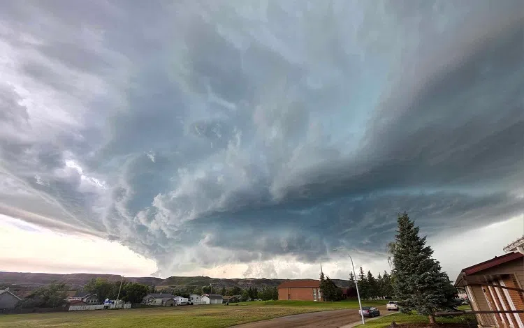
Things ramped up quickly and just before 6 PM significant activity developed around the Linden area and moved easterly into the Drumheller region. According to Stingray Weather Specialist Brandon Houck conditions were capable of generating a big storm like we received. “We had all the dynamics in place for potential supercells to develop. It was a little slow to get going but once the storm got going it went. It ramped up around the Acme / Linden area and moved in towards Carbon. The supercell produced golf ball to tennis ball sized hail, damaging winds as well. I wouldn’t be surprised if some areas had wind gusts of 120 km/h, looking at some of the damage. It weakened a little bit once it got to Drumheller but was still packing a punch south of the Drumheller. It was moving about 60 to 80 km/h.”
The target for the storm was the Town of Drumheller but the core ended up just south towards Horseshoe Canyon which saw large sized hail notes Houck. “That definitely was the area that got into the core of the storm, while Drumheller was in the weaker end, although it still packed a punch with torrential rain.” According to Environment and Climate Change Canada, at the Drumheller weather station, located across the highway from the water treatment plant, we received 21 millimetres of rain between 6 and 8 PM.
It was wave after wave of storms last night as a second storm hit the Drumheller area at about 6:30 PM. “That one was a lot weaker,” admits Houck. “This one developed way off the foothills. It was more of a squall line shelf cloud but it still moved very quickly. It was a much weaker storm and then there was wave three as well.” Houck admits that it is not that odd to have wave after wave of storms like we had on Wednesday night.
The cause of the storm was a cold front that rolled through shares Houck, and activity is not expected to be as intense today (Thursday). “The cold front has gone through. That was our trigger yesterday. You had the heat, humidity, cooler mass air following behind it, and that usually what spells trouble. Today, the cold front has gone through but we are still on the unsettled side. The odd storm may get pushed to severe limits today but I don’t expect anything to get as wild as yesterday. Sunday, that will be probably be our next chance for some stronger thunderstorms as we crank up the heat for the weekend.”
Comments